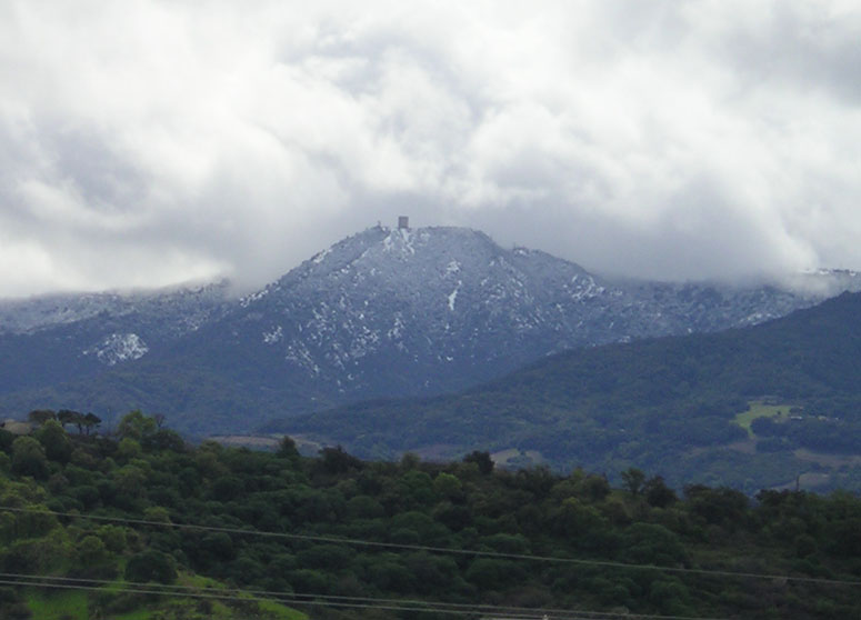
Mount Umunhum Summit
8.3Locals Score / 10#4 of 15 Parks & Outdoors in San Jose
Known formount umunhumsummitradar towerhiking
The 3,486-foot summit crowned by the iconic Cold War radar tower visible from all over Silicon Valley — opened to the public in 2017 after decades closed. Free, with a paved road to near the top, a ceremonial circle honoring Amah Mutsun heritage, and 360-degree views from the Bay to Monterey. The narrow mountain road is a commitment; check weather — the summit can sit in fog or wind.
Key facts
| Hours | Hours not verified |
|---|---|
| Price | free |
| Phone | — |
| Website | — |
| Nearest transit | None — car only via Hicks Rd and Mt Umunhum Rd from Almaden Valley (about 40-50 minutes from downtown San Jose) |
| Time needed | 2-4 hours including the drive |
| Best time to go | Clear fall and winter days for the sharpest 360° views; weekday mornings for parking |
| Last verified | July 12, 2026 |
Locals Score
8.3/10- Value9.5
- Iconic6.5
- Freshness5.9
- Crowd level8.0
- Authenticity9.0
- Accessibility5.0
Frequently asked questions
- How do I get to Mount Umunhum summit?
- Drive: from Almaden Valley take Hicks Road to Mt Umunhum Road, then about five paved but narrow and winding miles to the summit parking areas. There's no public transit and no legal roadside parking on the way up — it's the lot or nothing. Open 7am to a half-hour after sunset, free.
- What is the giant cube on top of Mount Umunhum?
- That's the radar tower from Almaden Air Force Station, which scanned for Soviet bombers from 1958 to 1980. The five-story concrete monolith was preserved when the summit opened to the public in 2017, and it's the South Bay's most recognizable landmark after... honestly, nothing — it is the landmark.
- Do I have to hike to reach the Mount Umunhum summit?
- No — you can drive to the upper parking area, and an accessible path leads to the summit viewpoints, making this one of the few big Bay Area summits available to wheelchairs and strollers. Hikers can instead climb the 3.7-mile Mount Umunhum Trail from the Bald Mountain parking area.
- How are the views from Mount Umunhum?
- On a clear day, genuinely 360 degrees: San Francisco Bay, the entire Santa Clara Valley, the Santa Cruz Mountains, and Monterey Bay. Crystal-clear days after winter storms are the jackpot. On foggy or hazy days you may see the inside of a cloud — check conditions before driving up.
- Can you go inside the Mount Umunhum radar tower?
- No — the tower is sealed and viewable only from outside. The summit instead offers interpretive exhibits about the Air Force station era, the east summit viewing area, and the ceremonial circle.
- Are dogs or bikes allowed on Mount Umunhum?
- No dogs in this area of Sierra Azul Preserve. Road cyclists do climb Mt Umunhum Road (it's a famously hard ascent), and bikes are allowed on the road and some trails — but the summit paths themselves are for feet.
- Is there water or food at Mount Umunhum?
- There are restrooms at the summit but no water or food, and no gas anywhere on the mountain. Bring layers regardless of the valley forecast — the summit runs 10-20 degrees colder and the wind can be serious.
- Why is Mount Umunhum sacred?
- Umunhum means roughly 'resting place of the hummingbird' in the Ohlone language, and the summit is sacred to the Amah Mutsun Tribal Band, who partnered with Midpen on a ceremonial circle there. Signs ask visitors to treat that space respectfully — do.
Nearby in Ask San Jose
- Almaden Quicksilver County ParkPark7.01 km · 88 min walk
- Dio DekaRestaurant9.69 km · 121 min walk
- Blossom Hill Farmers MarketMarket10.84 km · 136 min walk
- Psycho DonutsCafé11.78 km · 147 min walk
- Martial Cottle ParkPark12.58 km · 157 min walk
Where to stay near Mount Umunhum Summit
Compare hotels & stays on Booking.com · doesn’t affect the Locals Score